
It’s hard to believe that we’re already halfway through the fall semester, snow has fallen every day this week here in northern Vermont, and only now do I feel like I’ve gained enough distance and perspective on the incredible days I spent in the Faroe Islands at the end of July. How fleeting the weeks, and how full the days since then.
I spent most of August in Norway with a colleague and nine students from Sterling College on a field course that explored cultural and ecological resilience — from glaciology and tundra ecology to friluftsliv and trail maintenance to Sámi cultural traditions and foodways and reindeer husbandry. (More about that course in an upcoming post!)

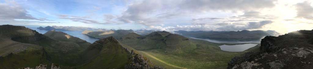
On July 25 and 26, I summited the highest peaks on all six of the islands in the Faroes that are directly accessible by car. After a rest day precipitated by poor weather, on July 28, I summited a seventh peak, Klubbin, on the tiny island of Fugloy at the eastern-most edge of the archipelago — only accessible by a small ferry.
There are 18 main islands in the Faroes, and given my relatively short timeframe, I had to choose which islands I would visit. I chose these 7 peaks because they are the highest on their respective islands and stand out as among the highest in Faroes.
Only two of the mountains I summited had distinct trails (Slættaratindur, which is the Faroes’ highest summit, and Villingadalsfjall, the northernmost summit, on the island of Viðoy), but most have no trails at all — only occasional footprints and braided trails carved into nearly every hillside by centuries of grazing sheep.

The peaks I summited are, in order of ascent:
Villingadalsfjall (844m) on Viðoy
Norðanfyri Lokkaskarð (772m) on Borðoy
Kuvingafjall (830m) on Kunoy
Slættaratindur (882m) on Eysturoy
Kopsenni (739m) on Streymoy
Árnafjall (722m) on Vágar
Klubbin (621m) on Fugloy
My original intent had been to run up and down all seven summits in a single day, but logistically this turned out to be unreasonable given the necessary ferries, the weather, and the timing — for one thing, the best weather day of my visit was my very first full day in the Faroes. Compounding jet lag with my late arrival, I wasn’t able to hit the trail up Villingadalsfjall until 10 am.
I rented a boathouse on Borðoy, so it made sense to approach the summits east to west, starting with Viðoy, then Borðoy, Borðoy, and finally Eysturoy as the midsummer sun hovered over the horizon. On the 26th, I made my way to the highpoints on Streymoy and Vágar on a mostly clear by increasingly windy day — wind which nearly turned back on Árnafjall when gusts of over 60 mph stopped me in my tracks on the final summit ridge. Even at the ocean far below, the Múlafossur waterfall was blown back up over its precipice on its way to the sea below.

Kuvingafjall
I tried to stay as close to a mountain running pace as possible, maintaining a steady jog on the infrequent low-angle terrain and often slowing to nearly a stop when faced with weaving through and around the cliff-bands that seem to encircle nearly all the summits here.
On Kuvingafjall, I came close, again, to turning back when confronted with the technical-looking headwall of cliffs encircling its summit. From a few kilometers away, the cliffs looked too consistently steep for any feasible ascent, but as I looked for a way to thread through them — or to find an alternative route up the neighboring Lokki — I saw (of course) a few sheep scattered in white and black garlands across the sparse high mountain pastures below the cliffs. If they could find purchase there, certainly I might be able to.

When I arrived there a the base of the first cliff band, I made my way gingerly across the loose scree and unconsolidated soil flecked with tufts of wind and weather-hardened grass. The sheep were gone, but their terraced footsteps remained to help guide me across the steep slope as I searched for a break in the cliff headwall. Finally, and much farther left then I had thought, I spied a break and followed it up, dangling my poles from my wrists so I could use handholds overhead. Another cliff band followed, and another, and another, until the angle of the slope started to abate, and before I knew it I was on a nearly entirely flat summit plateau that stretched for hundreds of meters in all directions. A boulder-strewn tabletop. It offered perhaps the least fulfilling view of all the seven peaks, but that wasn’t the point on Kuvingafjall — from the small square of forest in Kunoy to the ramparts protecting the summit, it was truly the way that was the most diverse of my Faroes adventure.
By the numbers
Roundtrip ascent & descents took from between 58 minutes (Slættaratindur — because of its well worn and graded trail) and 2 hours 44 minutes (Kuvingafjall — for its technical climbing and challenging route finding)
Total elevation gain (and equal descent): 15,900 ft
Total distance: 32.5 miles
Total time: 13 hours 31 minutes
It’s hard to choose any one experience in the Faroes to call a favorite — the isolation and long ridge line of Kopsenni, the difficulty of Kuvingafjall, the quiet and seclusion of Klubbin, the beauty of Árnafjall and its surroundings. Each peak was spectacular in its own way, and I’d love to explore some of the 11 islands I haven’t yet visited!

Environmental Change
The Faroes are uniquely situated at the point where the cold Arctic currents mix with the warmer Gulf Stream current, which helps to maintain an ideal environment for many species of marine life from whales to salmon, both of which are a staple food here. Even in the Faroes, despite their relative isolation, wild-caught fish are often too high in mercury for human consumption.
Researchers in the Faroes are grappling with global climate change on several fronts — looking at ways that the region’s strong tides can be used efficiently to produce electricity (with a goal of 100% renewable energy by 2030), and exploring what warming oceans will mean for stocks of cod and other fish (according to some research, an average increase of 4 degrees C in the North Atlantic is predicted to result in a near collapse of Cod stocks in southern and central Scandinavia).
At the base of Norðanfyri Lokkaskarð, I ran through the construction site of what will soon be the largest smolt farm in the world. Smolt, or juvenile salmon, are often put into fjord-based salmon farms when they are fairly small — 120 grams. By increasing the size of the smolts (to 500 grams) prior to moving them to the open sea, Bakkafrost hopes to decrease the incidence of disease, lice, and mortality.
At the same time, the Klaksvik-based company also manufactures polystyrene packing containers to ship its farmed salmon worldwide, thereby potentially contributing to the microplastic marine pollution that jeopardizes the very environment that is key to raising healthy salmon. Marine polystyrene fragments have been found worldwide, thanks to their high buoyancy, and have even been connected to bioaccumulating concentrations of mercury in the Baltic Sea.
While the Faroes are often seen as a wild and remote place — isolated and far removed from the unebbing tide of pollution, greenhouse gas production, and the economic/environmental binary that seems to underlie nearly all western culture — it is clear that the Faroes are both a beautiful, remote, and striking place with deep and unique cultural traditions and a participant in the systems that continue to challenge ecological systems around the world.
In this way, the Faroes are emblematic of a place, people, and way of life caught at the nexus of complex global economic and ecological systems — the challenges are immense, the problems incredibly complex, but if there’s any real hope, it is in our need to understand and our desire to do the best we can with the time that we have.

- Leaving Fugloy with the summit of Klubbin clearly visible on the left of the island.


Leave a comment